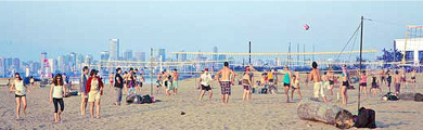
Kitsilano, known locally as Kits, is synonymous with famous Kits Beach—named one of the “top 10 best city beaches in the world” by international travel magazines, and perfect for outdoor fitness. Kitsilano is one of the city’s organic-food hubs, and has extensive restaurants and retail along West 4th Avenue and West Broadway. Kitsilano runs along the south shore of English Bay, between popular Granville Island and Point Grey.
Neighourhood history and heritage
 At the turn of the century, the area from Burrard to Alma Streets was a dense, wild-life-filled forest, in spite of earlier logging. A salmon canning factory at the foot of Macdonald Street was once unable to cope with the “hundreds of thousands of salmon” caught in 1900.
History
During the summer, dozens of vacationing tent campers — many from the city’s fashionable West End — lined Kits Beach, then called Greer’s Beach after one of the area’s earliest settlers. East of the beach area was the Kitsilano Indian Reserve, on the site of today’s Vanier Park. The Coast Salish village of Snauq was located on the shore of False Creek, slightly to the east of the Museum-Planetarium Complex.
The CPR (which owned most of the land east of Trafalgar), the B.C. Electric Railway’s streetcar line along 4th Avenue to Alma, and the Burrard Bridge built in 1932, all played a role in opening up Kitsilano. However, Kitsilano was not fully developed south to 16th Avenue until the late 1940s. During World War II, most of the old estates and many single-family homes along the slope above Kitsilano Beach were converted into rooming houses. They remained that way until the 1960s, by which time the area had become popular with university students and young people from throughout North America.
Kitsilano residents have a long history of community involvement. As early as 1907, Kitsilano citizens lobbied for sewers, tram service and other infrastructure for their community. A rezoning of the slope above the beach to allow apartments raised residents’ concerns over the future of their community. Further changes in the 1970s, and again in the 1980s, prompted City Council to initiate local area planning programs involving Kits residents, local business people and City staff.
Heritage
In the past three decades, there have been numerous physical changes in the Kitsilano area. The most dramatic have occurred in the apartment area, where most original houses have been replaced by new apartment buildings. In the duplex/conversion areas of Kits however, residents have been working hard to restore and preserve the character homes which make the community so distinctive.
Concentrations of Craftsman-style houses can be found in the area bounded by Macdonald, Stephens, 5th and 6th Avenues. A virtually intact row of “California Bungalows” can be seen on the south side of 5th Avenue between Bayswater and Balaclava. In recognition of the special quality of these (duplex/conversion) areas, City Council has adopted changes to the Zoning and Development By-law to assist the retention of older character homes. These changes include:
- allowing the conversion of large, old homes into multiple suites in designated areas: and
- offering bonuses for sensitive new building designs as well as for the renovation of heritage buildings.
Another community landmark is the tiny Arbutus Grocery at the corner of 6th Avenue and Arbutus Street. The building has a boomtown facade and an unusual corner entry. It was built in 1907 by Thomas F. Frazer and is one of the finest old grocery stores in the city.